IKONOS History
IKONOS comes from the Greek word for "image". Ikonos-1 was scheduled for launch in 1999, but the launch failed. Ikonos-2 was scheduled for launch in 2000, but was renamed Ikonos and was on 24 September 1999 by Space Launch Complex 6 (SLC-6) at Vandenberg Air Force Base in California to replace Ikonos-1. The imaging sensors are panchromatic and multispectral. This satellite has a polar, circular saws, sun-synchronous 681-kilometer orbit and the two sensors have a swath width of 11 km. Its weight is 1600 pounds (720 kg). Space Imaging was ORBIMAGE to GeoEye.
 About IKONOS
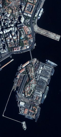
The IKONOS Satellite is a high-resolution satellite operated by GeoEye. Its capabilities include capturing a 3.2m multispectral, Near-Infrared (NIR)/0.82m panchromatic resolution at nadir. Its applications include both urban and rural mapping of natural resources and of natural disasters, tax mapping, agriculture and forestry analysis, mining, engineering, construction, and change detection. It can yield relevant data for nearly all aspects of environmental study. IKONOS images have also been procured by SIC for use in the media and motion picture industries, providing aerial views and satellite photos for many areas around the world. Its high resolution data makes an integral contribution to homeland security, coastal monitoring and facilitates 3D Terrain analysis.
 When GeoEye successfully launched the IKONOS® satellite in 1999, it made history with the world’s first one-meter commercial remote sensing satellite. Since then, GeoEye has set the standard for quickly delivering large volumes of tonally balanced, map accurate, mosaicked images for a variety of industries and applications. To date, IKONOS, derived from the Greek word for "image," has collected more than 275 million square kilometers of imagery that is readily available in our digital archive.
 Moving over the ground at approximately seven kilometers per second, IKONOS collects black-and-white and multispectral data at a rate of over 2,000 square kilometers per minute. IKONOS satellite imagery provides access to any location on the Earth’s surface. Through the nearly fifteen, 98-minute journeys it makes around the globe each day, IKONOS collects vital statistics about the Earth’s ever-changing features—from fluctuations in land and water resources to the build-out of new urban areas. Commercial and governmental organizations rely on GeoEye’s high-resolution imagery to view, map, measure, monitor and manage global activities. Applications range from national security and disaster assessment to urban planning and agricultural monitoring. Drawing on the spectacular views from IKONOS, the possibilities are endless.
- Wikipedia, IKONOS.
- Satellite Imaging Corporation, Ikonos Satellite Images and Sensor Spesifications.
- ITT, IKONOS Satellite.
- GeoEye, Image Product IKONOS.